
Landslide Detection and Mapping Using Deep Learning Across Multi-Source Satellite Data and Geographic Regions
Published in arXiv preprint arXiv:2507.01123v2, 2025
Summary
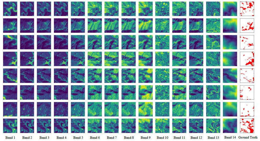
Landslides are one of the most destructive natural hazards, causing major damage to infrastructure, the environment, and human lives. In this research, we explore how modern deep learning techniques and satellite-based remote sensing can help improve landslide detection and prediction. By combining Sentinel-2 multispectral imagery with ALOS PALSAR slope and Digital Elevation Model (DEM) data, our approach captures important environmental factors such as terrain structure, vegetation cover, and rainfall patterns that contribute to landslide events.
We also compare the performance of several advanced deep learning segmentation models, including U-Net, DeepLabV3+, and ResNet, to identify the most effective method for automated landslide mapping. The goal of this work is to support the development of more reliable early warning systems, smarter disaster management strategies, and sustainable land-use planning. Our findings highlight the growing potential of AI-powered remote sensing in building scalable and accurate landslide prediction systems for real-world applications.
Quick Links & Resources
![]()
![]()
![]()
![]()
Visual Representation
BibTeX Citation
@article{shinde2025landslide,
  title={Landslide Detection and Mapping Using Deep Learning Across Multi-Source Satellite Data and Geographic Regions},
  author={Shinde, Harsh and Burange, Rahul and Mutyalwar, Omkar},
  journal={arXiv preprint arXiv:2507.01123v2},
  year={2025},
  url={https://arxiv.org/abs/2507.01123v2}
}